


la motte le capelan

clintest
User
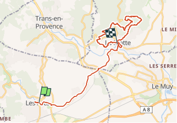

Length
19.6 km

Max alt
248 m

Uphill gradient
409 m
Km-Effort
25 km

Min alt
53 m

Downhill gradient
426 m
Boucle
No
Creation date :
2023-03-24 14:50:31.889
Updated on :
2023-03-28 12:25:36.296
10h20
Difficulty : Very difficult

FREE GPS app for hiking
 SityTrail
IGN / Geographical institutes
SityTrail Plus
The world is yours!
About
Trail Walking of 19.6 km to be discovered at Provence-Alpes-Côte d'Azur, Var, Les Arcs-sur-Argens. This trail is proposed by clintest.
Positioning
Country:
France
Region :
Provence-Alpes-Côte d'Azur
Department/Province :
Var
Municipality :
Les Arcs-sur-Argens
Location:
Unknown
Start:(Dec)
Start:(UTM)
296150 ; 4815320 (32T) N.
Comments